Zurich’s trams carry visitors across the city, but many of the last steps to a hotel, café, or museum still happen on foot. This project used the city’s pedestrian network to ask three practical questions: how much of Zurich lies within a 10-minute walk of a hotel, which café is closest to each tram stop, and what route connects five central museums most efficiently.
Rather than measuring straight-line distance, each analysis followed walkable paths through the street and footpath network.

Data and network preparation
The analysis combined points of interest from OpenStreetMap with pedestrian-network and public-transport data from the City of Zurich.
| Layer | Source | Dataset or service |
|---|---|---|
| Points of interest | Geofabrik | Switzerland |
| Pedestrian network | City of Zurich | Footpath and cycle path network |
| Public transportation | City of Zurich | Public transport lines and stops |
| Zurich municipal boundary | Esri | Town and City Perimeters: Switzerland and Liechtenstein |
All spatial data were accessed in July 2025, clipped to the Zurich boundary, and projected to CH1903+ / LV95. The pedestrian network was configured to measure travel in walking minutes, assuming a speed of 5 kilometers per hour.
A 10-minute walk from Zurich hotels
The first analysis used ArcGIS Pro’s Service Area tool to identify locations reachable within a 10-minute walk of each hotel. The resulting polygons represent walkable catchments rather than simple circular buffers: their shapes follow the connected pedestrian network.
Bakery and nightclub locations were overlaid with the catchments to evaluate access to nearby amenities.
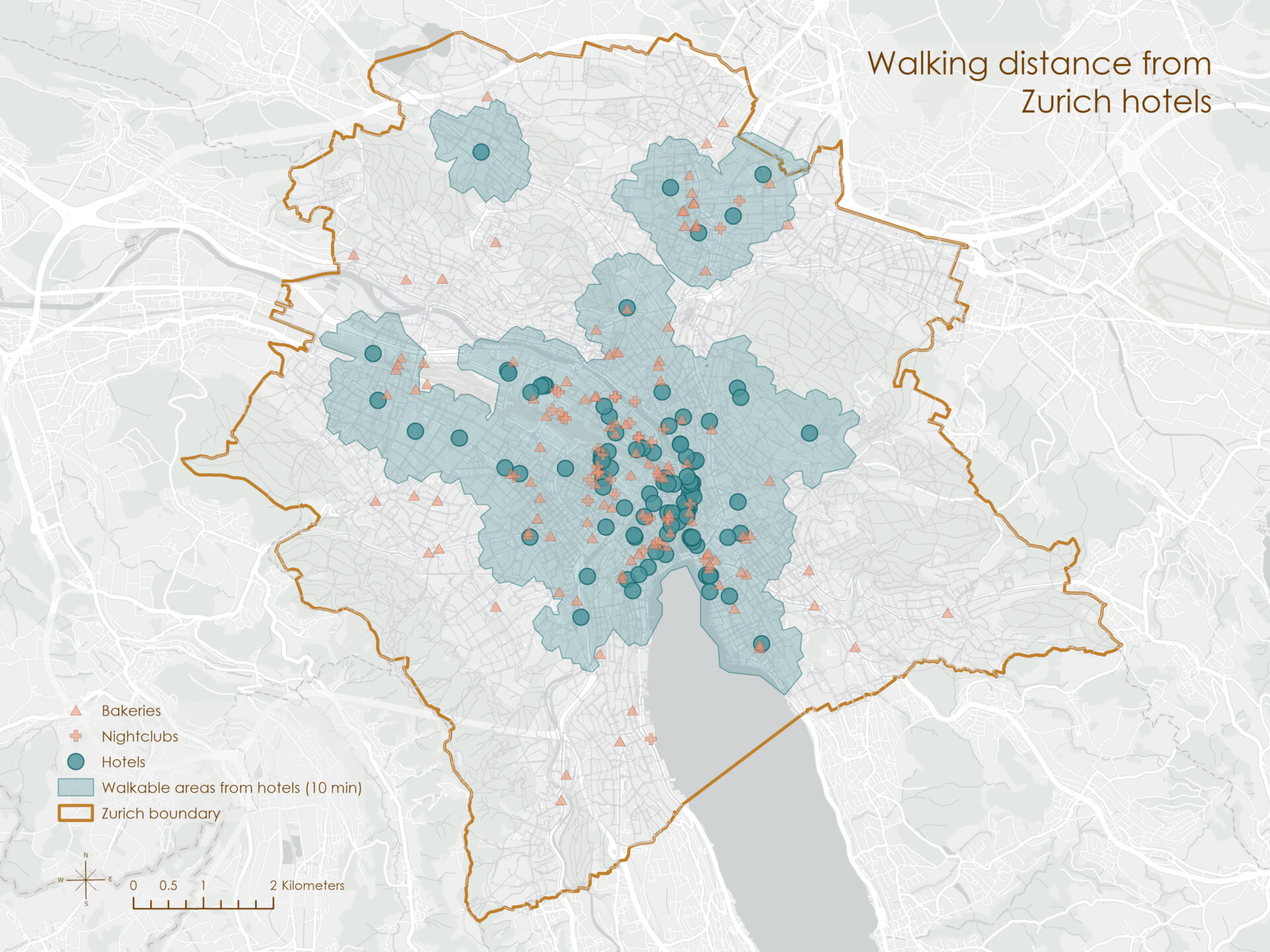
Of the 151 bakeries in the city, 90 fell within at least one hotel catchment. The same was true for 36 of 37 nightclubs. Coverage was strongest in central Zurich, where numerous hotel catchments overlap and most of the selected amenities were within a short walk.
The nearest café from each tram stop
The second analysis treated tram stops as origins and cafés as destinations. ArcGIS Pro’s Closest Facility tool calculated the shortest walking path from each stop to its nearest café.
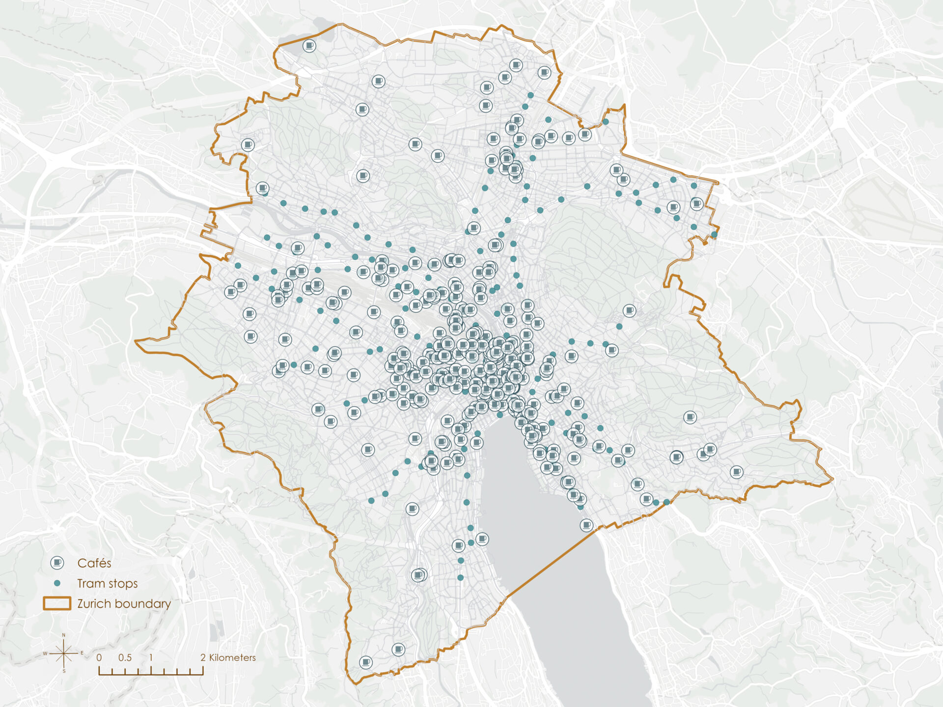
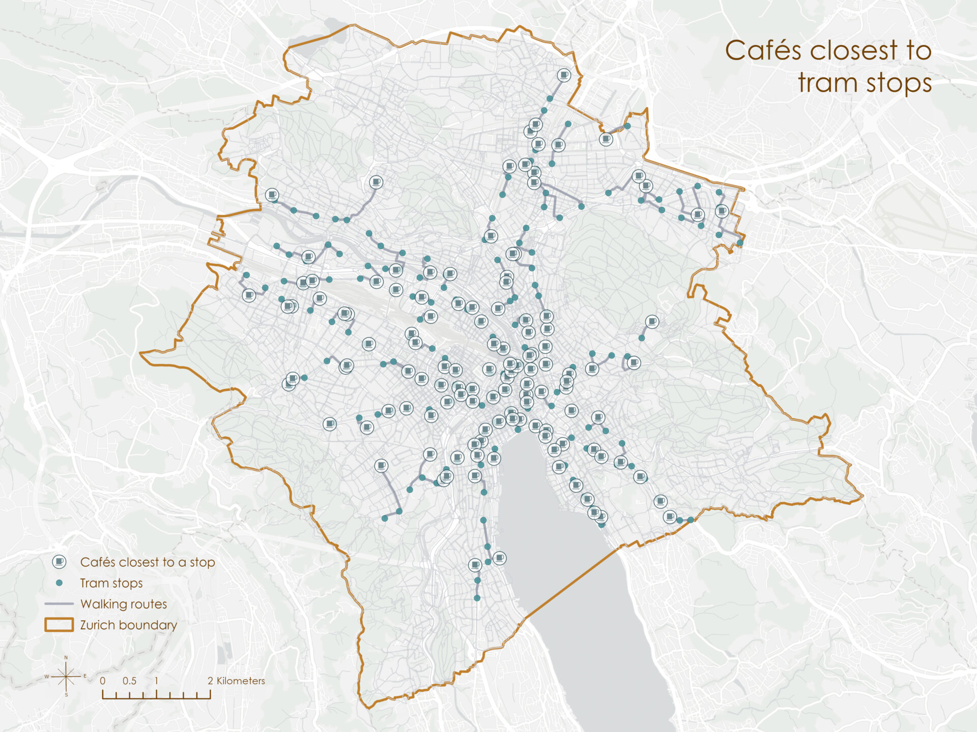
Some cafés were the nearest destination for multiple tram stops, making them particularly well connected to the public-transport network.
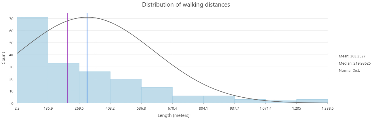
Nearly all routes were shorter than 1 kilometer, suggesting that most tram stops in the analysis had a café within a relatively brief walk.
An efficient route through five museums
The final analysis asked how to visit five museums with the least total walking time while beginning at the Zurich Museum of Art (Kunsthaus Zürich). ArcGIS Pro’s Route tool solved a traveling-salesperson-style problem, preserving the first stop while determining the most efficient order for the remaining destinations.
The route included:
- Zurich Museum of Art
- Landesmuseum Zürich
- Natural History Museum of the University of Zurich
- Museum of Design
- Uhrenmuseum Beyer
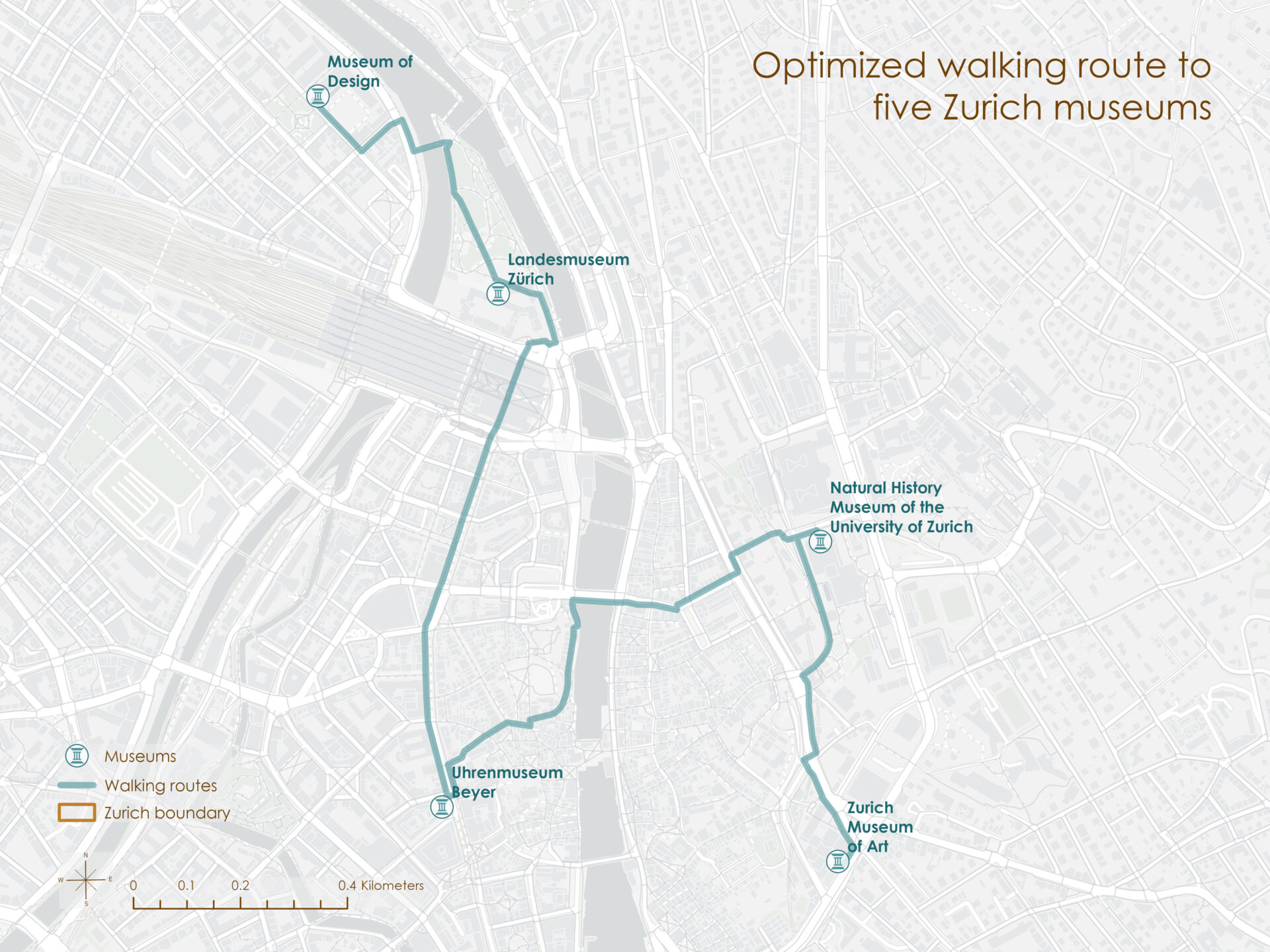
The optimized route covered approximately 3.6 kilometers with a modeled walking time of 46 minutes. It connected museums on both sides of the Limmat while providing a compact itinerary through central Zurich.
What the network reveals
The three analyses approached pedestrian access at different scales: areas reachable from many origins, the nearest destination from each transit stop, and one ordered trip through multiple destinations. Together, they show how a routable pedestrian network can turn point locations into practical measures of access and movement.
The results describe modeled rather than universal walking conditions. They reflect the available network, an assumed walking speed of 5 kilometers per hour, and data accessed in July 2025. Slope, temporary closures, crossing conditions, and individual mobility needs could all affect the experience of walking these routes.
Citations
City of Zurich. (2025). Footpath and cycle path network [Data set]. https://data.stadt-zuerich.ch/dataset/geo_fuss__und_velowegnetz
City of Zurich. (2025). Public transport lines [Data set]. https://data.stadt-zuerich.ch/dataset/ktzh_linien_des_oeffentlichen_verkehrs__ogd_
City of Zurich. (2025). Public transport stops [Data set]. https://data.stadt-zuerich.ch/dataset/ktzh_haltestellen_des_oeffentlichen_verkehrs___ogd_
Esri. (2025). Town and City Perimeters: Switzerland and Liechtenstein [Data set]. ArcGIS Living Atlas of the World. https://www.arcgis.com/home/item.html?id=d58ae34570ff4fb9a2456e94dbd5563d
Geofabrik. (2025). Switzerland [Data set]. Geofabrik Downloads. https://download.geofabrik.de/europe/switzerland.html
Categories: Mapping, Spatial data management, Spatial analysis