Zurich is a major tourist destination, but are key attractions accessible by foot?
This project used network analysis techniques to analyze the pedestrian accessibility of attractions and built an optimized route for a museum walking tour.
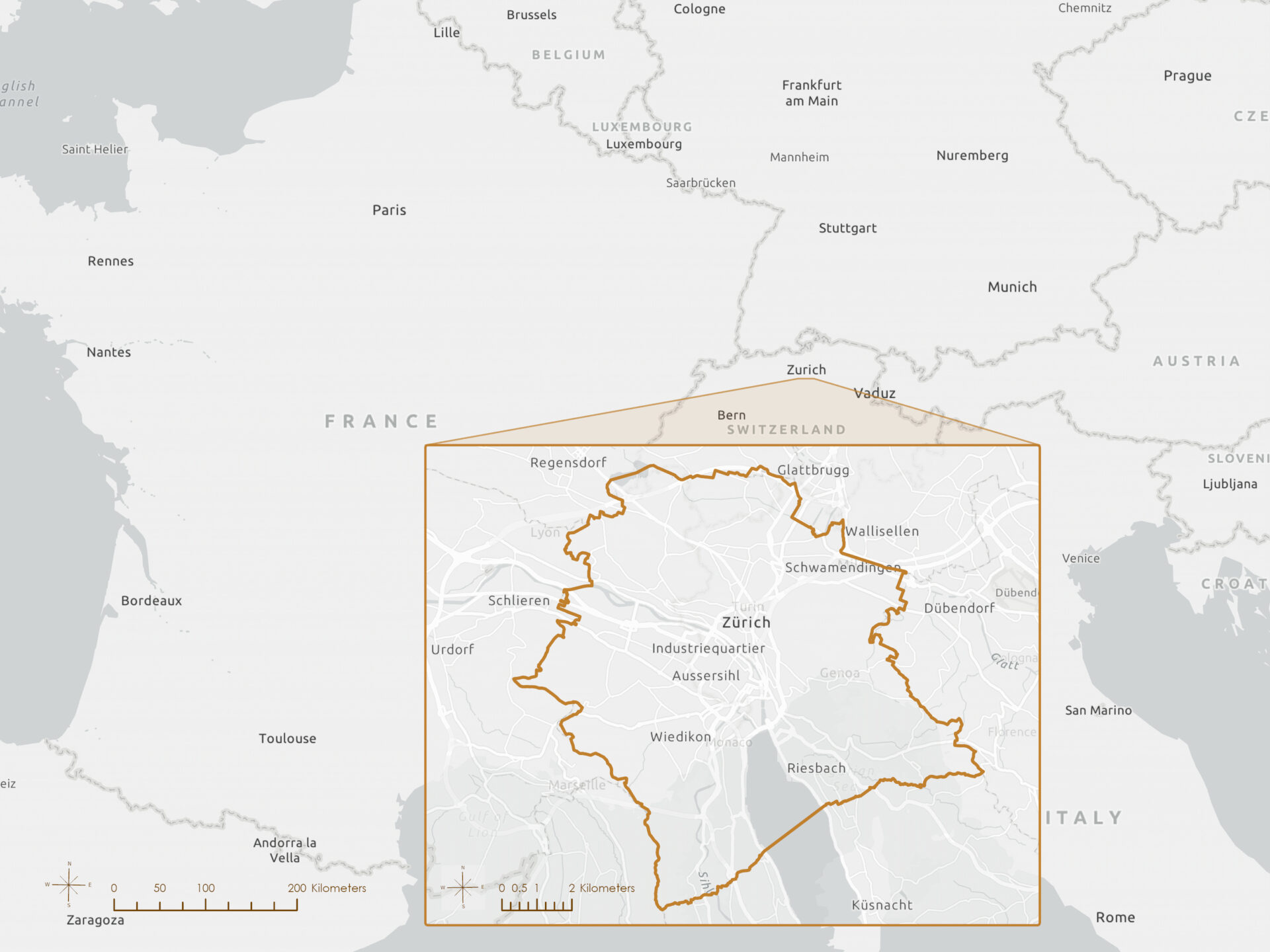
Study area
Data
This analysis drew on publicly available GIS datasets from the City of Zurich Open Data catalog and OpenStreetMap.
| Layer | Source | Dataset / service |
|---|---|---|
| Points of interest | Geofabrik | Switzerland |
| Walking network | City of Zurich | Footpath and cycle path network |
| Public transportation | City of Zurich | Public transport lines and stops |
| Zurich boundary | Living Atlas | Town and City Perimeters Switzerland and Liechtenstein |
All spatial data were downloaded in July 2025, clipped to the Zurich boundary, and projected to CH1903+ / LV95 (Hotine Oblique Mercator Azimuth Center) prior to analysis.
Service Area network analysis
Which areas of Zurich were within a 10-minute walking distance from hotel locations?
Using ArcGIS Pro’s Service Area network analysis tool, walkable accessibility was modeled from hotel locations. A pedestrian network dataset with travel impedance set to time (minutes) was used, assuming a walking speed of 5 km/h.
The resulting polygons represent 10-minute walkable catchment zones around hotel locations in Zurich. To evaluate pedestrian access to nearby amenities, bakery and nightclub points were overlaid with these service areas.
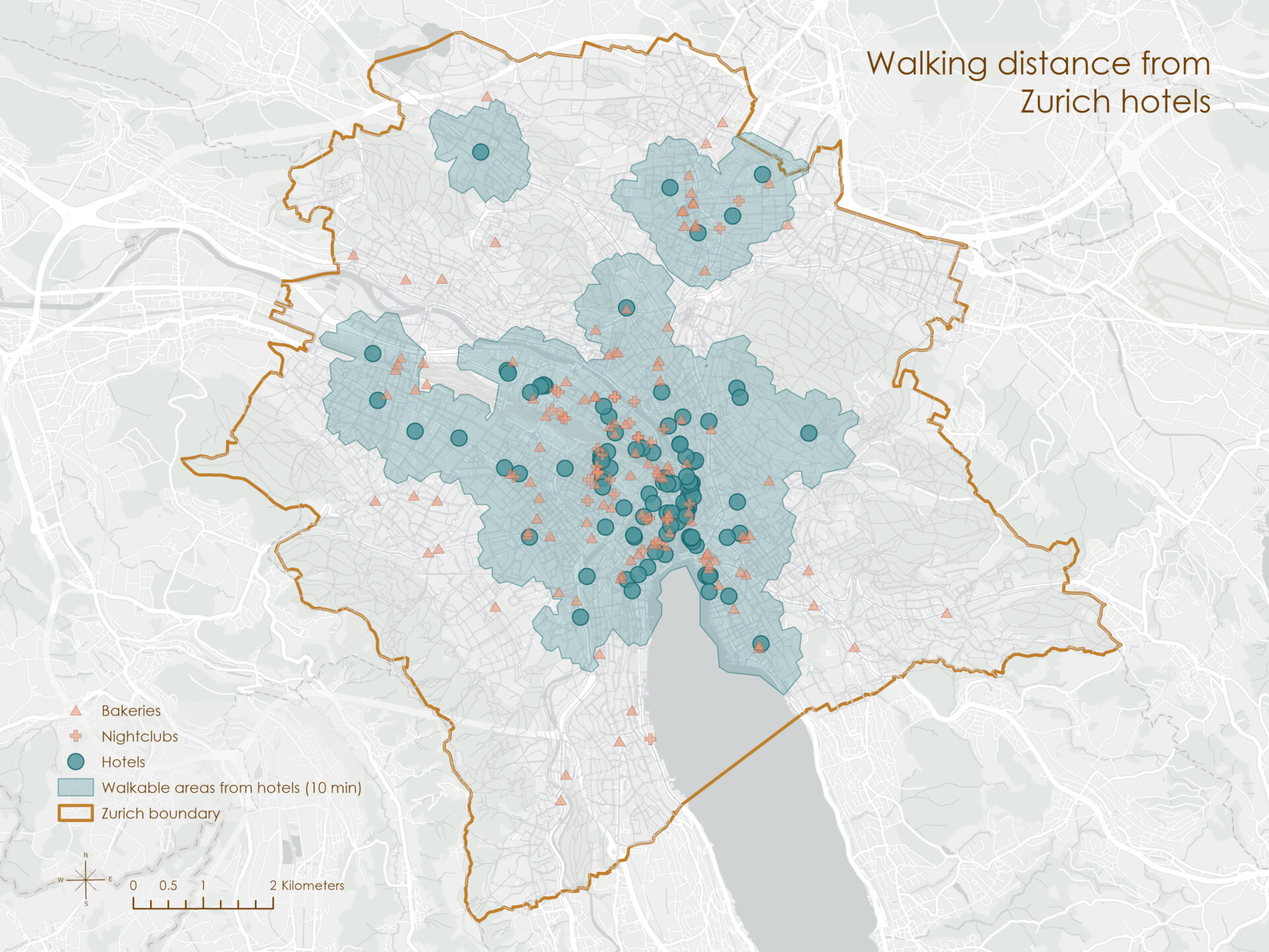
The analysis shows that hotel coverage is particularly strong in central Zurich, where catchment areas densely overlap. Of the total 151 bakeries in the city, 90 (79%) fell within the catchment area, and 36 of 37 (97%) of the nightclubs fall within a 10-minute walking distance from at least one hotel, indicating a high degree of walkable access for tourists staying in the city center.
Closest Facility network analysis
What was the closest café to reach on foot from each tram stop?
The Closest Facility analysis was run in ArcGIS Pro using tram stops as the incidents and cafés as the facilities.
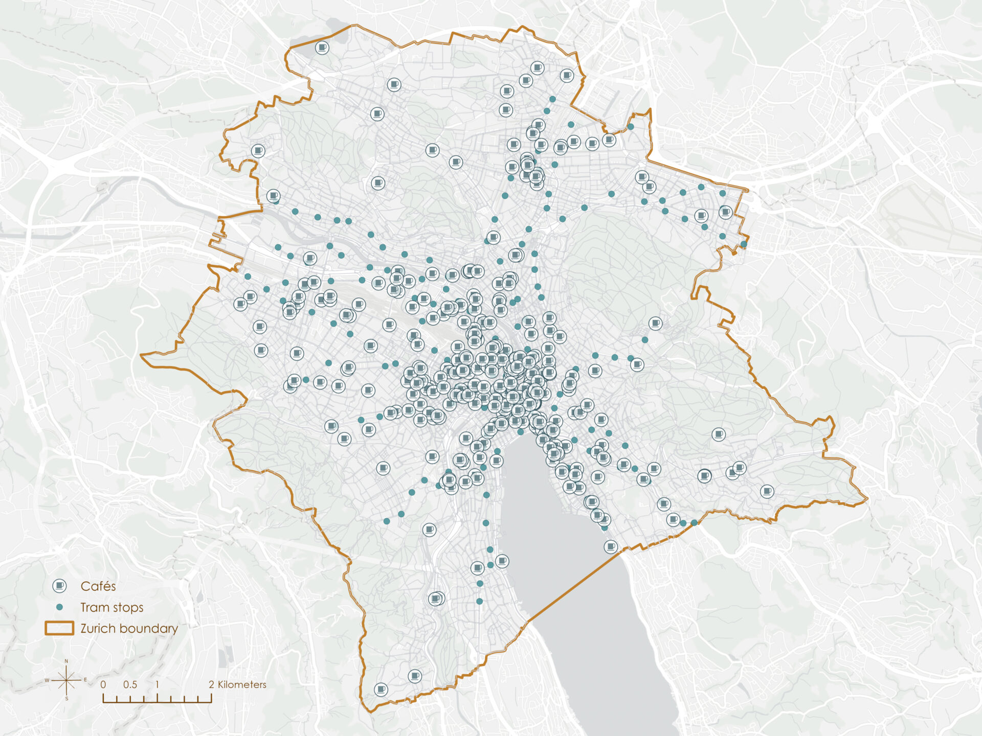
The impedance was set to walking time, again using the pedestrian network. The tool calculated the shortest walking path from each stop to its nearest café, highlighting ease of access for transit riders.
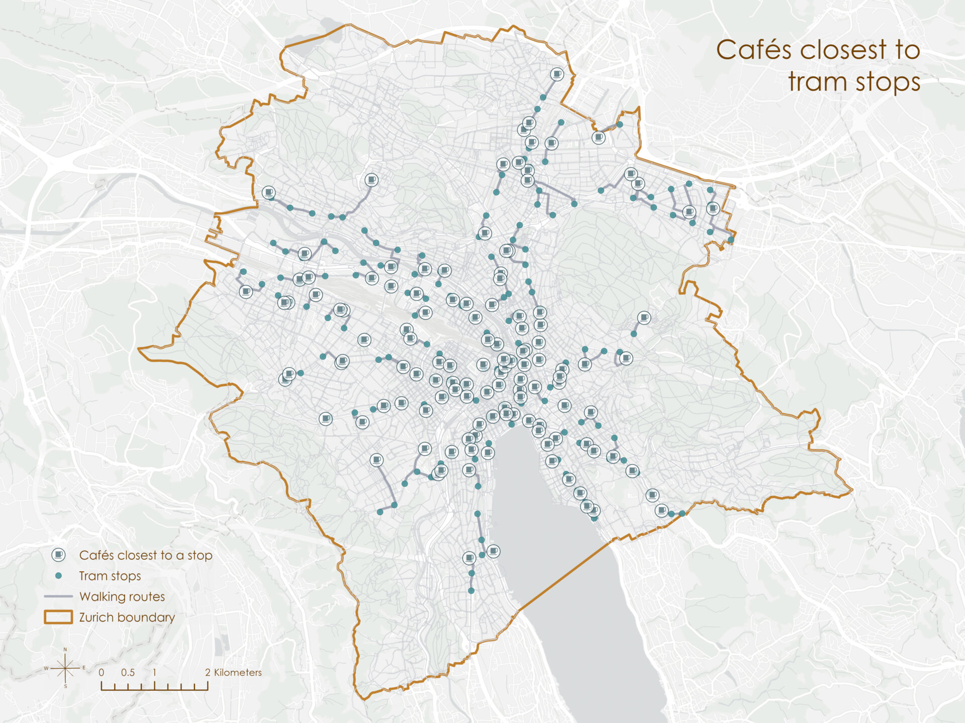
The analysis identified 183 cafés as the closest destinations to tram stops across Zurich’s network. Several cafés serve multiple tram stops, highlighting their importance as walkable access points for public transit users.
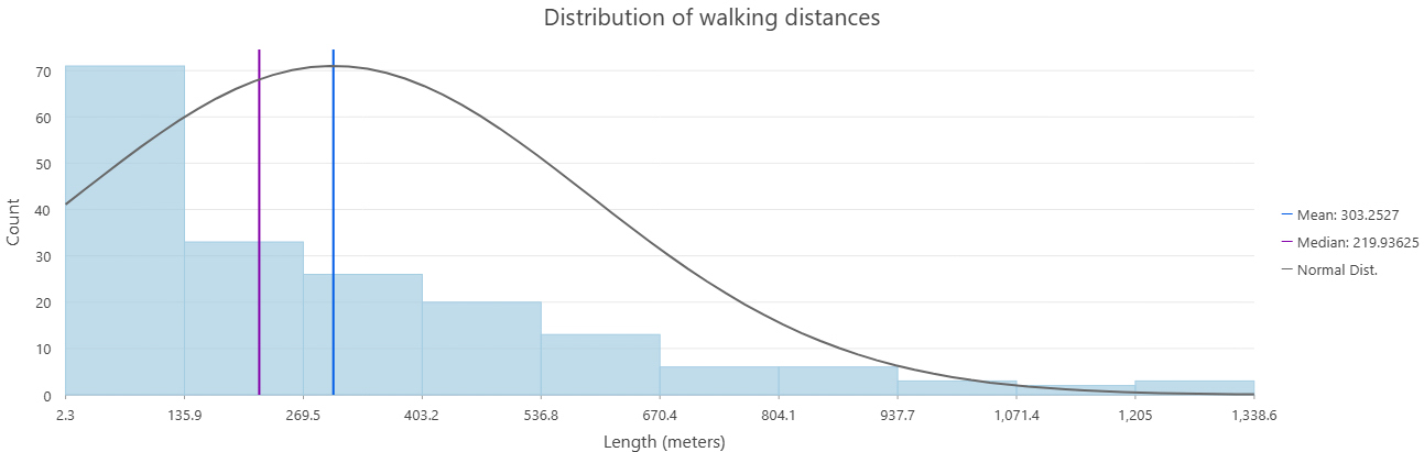
The walking distance from tram stops to their nearest café was generally short: the median distance was approximately 220 meters, and the mean just over 300 meters. Nearly all routes fell within 1 km.
Optimized Route network analysis
What was the most efficient walking route to visit five museums in central Zurich, starting at Kunsthaus Zürich (Zurich Museum of Art)?
ArcGIS Pro’s Route analysis tool was used to solve a traveling salesperson–style problem: determining the most time-efficient walking route to five major museums. Stops were ordered using the “Preserve First Stop” option, and the pedestrian network’s time cost attribute was used for impedance.
Museums included:
- Zurich Museum of Art
- Landesmuseum Zürich
- Natural History Museum of the University of Zurich
- Museum of Design
- Uhrenmuseum Beyer
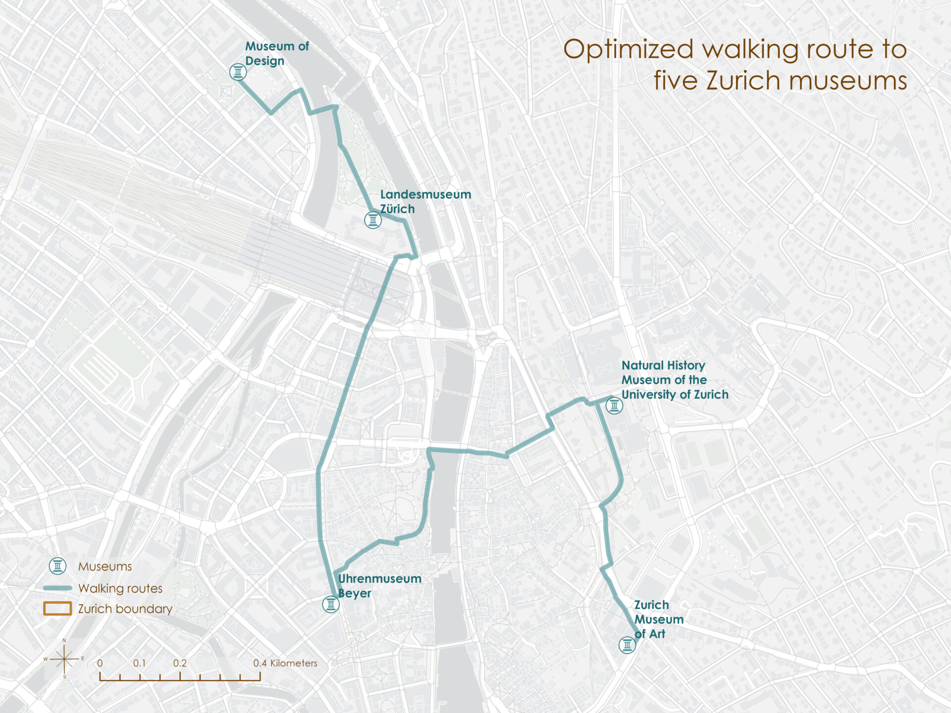
The optimized route spanned approximately 3.6 kilometers with a total walk time of 46 minutes. It traveled efficiently through the museum cluster north of the Limmat River, providing a logical and enjoyable itinerary for cultural meandering.
Conclusion
This project demonstrated the value of network analysis for assessing tourist accessibility and planning optimized cultural experiences. By modeling service areas, nearest amenities, and multi-stop walking routes, city planners can enhance the walkability and visitor-friendliness of Zurich.
Software and tools
This analysis was conducted using ArcGIS Pro 3.5.2, with an emphasis on the Network Analysis tools, and Google Earth Engine (GEE) for remote sensing data access and pre-processing.
All spatial data were downloaded in July 2025 and projected to CH1903+ / LV95 (Hotine Oblique Mercator Azimuth Center) prior to analysis.
Citations
City of Zurich. (2025). Footpath and cycle path network [Data set]. https://data.stadt-zuerich.ch/dataset/geo_fuss__und_velowegnetz
City of Zurich. (2025). Public transport lines [Data set]. https://data.stadt-zuerich.ch/dataset/ktzh_linien_des_oeffentlichen_verkehrs__ogd_
City of Zurich. (2025). Public transport stops [Data set]. https://data.stadt-zuerich.ch/dataset/ktzh_haltestellen_des_oeffentlichen_verkehrs___ogd_
Geofabrik. (2025). Switzerland [Data set]. https://download.geofabrik.de/europe/switzerland.html
Living Atlas. (2025). Town and City Perimeters: Switzerland and Liechtenstein [Data set]. https://www.arcgis.com/home/item.html?id=d58ae34570ff4fb9a2456e94dbd5563d